New map boosts China's claim in sea
发布时间: 2014-08-05 | 阅读数:Note
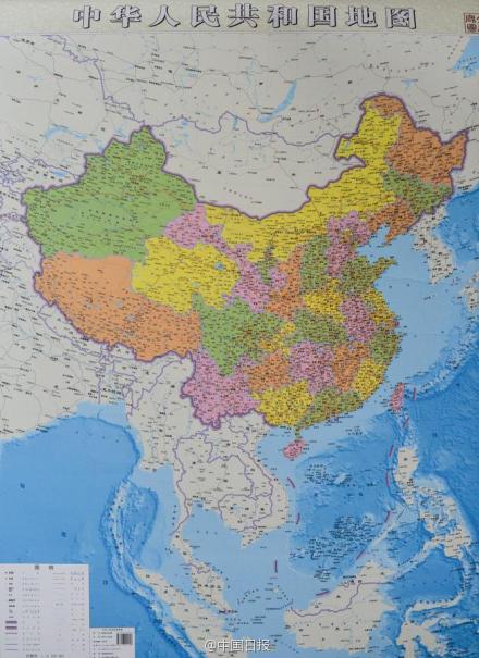
Sinomaps press has recently published a vertical map of China giving equal weight to land and sea areas. The new map is different because, unlike traditional horizontal maps that show the islands in the South China Sea in cut-away boxes in a bottom corner, it gives a good idea of China's land and sea territories at a single glance, and thus strengthens its territorial claims. The new map shows 10 segments of line, neither nine, nor eleven segments. In recent years, the international community followed the Chinese people’s customary references to the U-shaped line-“nine-sectioned line”, “broken line” or “dotted line”, and even gave it a disagreeable term, “cow tongue line”. These expressions in English basically convey that the boundary is informal and is demarcated randomly and indicate a sense of contempt and despise, which would be unfavorable to China in its publicity efforts. Currently, many foreigners challenge China’s stance on this issue on the ground that the demarcation of the boundary lacks legal bases. Hence, China should adopt the formal name “U-shaped line”, which is frequently referred to in English-speaking countries, and make abundant interpretations on the complex issue of its legal attribute, so as to create favorable conditions for China’s international publicity. The arguments for this recommendation are as follows:
1. The line has not been comprised of only nine sections since beginning. The Chinese government in 1946 drew and publicized the Location Map of Chinese Islands in the SCS after prudent navigational survey and research; the SCS boundary demarcated in this map was the “eleven-sectioned line”. It was not until 1952 that the “nine-sectioned line” emerged. Therefore, if China keeps naming it as “nine-sectioned line”, it means to ignore the Chinese government’s official proclamation on “eleven-sectioned line” in 1946, which would put off China’s official claim by six years and also pose unfavorable effects on China’s stance in inheriting the rights.
2.The expression of “traditional ocean boundary” is not conventionally used in modern international law; instead, the U-shaped line should be adopted as an abbreviation for daily use and the waters within the boundary should be defined as China’s historic waters. In other words, the official name for the boundary is the “outer limit of China’s historic waters in the SCS”, and could be abbreviated as U-shaped line.
In conclusion, the often misused name of the “nine dash line” no longer corresponds to the reality; the “U-shaped line” should be used as a more decent name of the outer limit of China’s historic waters in the SCS.
By Kuenchen FU(XMU-SCSI Professor)
Zhen LIN (XMU-SCSI Assistant Professor)
Hong CHANG (XMU-SCSI Assistant Professor)短评
不久前,中国地图出版社独家推出的竖版中国地图首次将南海诸岛同比例展示出来,把海洋和陆地放在了同样重要的位置,全景展示了中国的陆海疆域。新版地图明确标明了十段线段,既非九段,也不是十一段。近年来,国际社会上对于中国南海传统U形海疆线的称呼各不相同: “九段线”、“断续线”或“虚线”,甚至在有些国家恶意地称之为“牛舌线”。这些用语在英文语意上基本都是“非正式的”、“随便乱划而成的”,暗示轻蔑之意。这在宣传上对中国是不利的。目前诸多外国人士也往往以这条线的划定欠缺法律基础来挑战中国的立场。因此,中国首先应该正名,应该尽量使用英语世界惯用的“U形线”这一名称,并对其复杂的法律属性给予充分的解释,这样比较有利于中国的国际宣传。这样建议的理由如下:
1.这条线并非自始只有九段。1946年中国政府经过了慎重的航行调查研究,划定并公告了《南海诸岛位置图》,当时图中标明的南海疆界线是十一段线。直到1952年以后,才在新中国出现所谓的“九段线”。所以如果中国总是称之为“九段线”就等于自我忽略了1946年的正式公告,不但白白延后了至少6年的官方正式主张时间,也对持续中国国家继承权利的立场造成不良的国际法效果。
2.用“传统海疆线”的称呼不符合现代国际法的习惯用语,不如用“U形线”来作为日常用语中的简化称呼,并将其线内水域定性为中国的“历史性水域”较妥。换言之,这条南海传统海疆线的正式名称就是“中国在南海的‘历史性水域’的外部界线”,平常简称之为“U形线”。
因此,过去常用的所谓“九段线”已经明显不符合实际;而“U形线”作为“中国在南海‘历史性水域’的外部界线”的简称应该是比较更得体、适用的名称。
评论人: 傅崐成(厦门大学南海研究院教授)
林蓁(厦门大学南海研究院助理教授)
常虹(厦门大学南海研究院助理教授)
New map boosts China's claim in sea
By Wang Junming (China Daily)
A local publishing house in China has published a vertical map of the country giving equal weight to land and sea areas. The new map is different because, unlike traditional horizontal maps that show the islands in the South China Sea in cut-away boxes in a bottom corner, it gives a good idea of China's land and sea territories at a single glance, and thus strengthens its territorial claims.
The map, however, has evoked strong reactions from Vietnam and the Philippines. The two countries have criticized China's "unreasonably expansive claim" and urged it to respect international laws. Besides, Philip Goldberg, the US ambassador to the Philippines, has said China's "artificial creations" have no basis in international law.
Contrary to the accusations, the publication of the map can help promote Chinese public's territorial awareness and high-light its historic title over the South China Sea and is thus a legitimate move.
This is not the first time these countries have questioned China's historic title over the South China Sea or wrongly accused Beijing of violating the United Nations Convention on the Law of the Sea. China is a party to the UNCLOS and has been adhering to its principles. Moreover, there is no conflict in China abiding by the UNCLOS and substantiating its sovereign claim over the islands and the adjacent waters by high-lighting its historic title. After all, reference to historic titles is part of the UNCLOS.
Historic title generally signifies the rights a state has had over certain waters for a considerable time, which can be sovereign rights or other non-exclusive rights unrelated to territorial sovereignty such as traditional fishing rights. From the perspective of the UNCLOS, historic title is considered an exception to the applicability of the provisions on sea boundary delimitations.
For instance, according to Article 10 of the UNCLOS, related provisions on bays do not apply to the so-called historic bays, and Article 15 says provisions on the delimitation of the territorial sea between states with opposite or adjacent coasts do not apply "where it is necessary by reason of historic title or other special circumstances". Article 47 stipulates that, "if a part of the archipelagic waters of an archipelagic state lies between two parts of an immediately adjacent neighboring state, existing rights and all other legitimate interests which the latter state has traditionally exercised in such waters" shall continue and be respected.
China has a long history of exploring and exploiting the South China Sea and, hence, has historic title over the sea, which is proven by the nine-dash U-shaped line marked on official maps since the 1940s. Although China's Exclusive Economic Zone and Continental Shelf Act says conflicting claims on the exclusive economic zone and the continental shelf by China and countries with opposite or adjacent coasts shall be settled on the basis of international law, it clarifies that "the provisions of this act shall not affect the historical rights of the People's Republic of China".
With historical rights over the South China Sea, China is entitled to draw the baselines for measuring the territorial sea of the islands in the South China Sea. In fact, in September 1958 China issued the Declaration on the Territorial Sea, which states that China's territorial sea along the mainland and its coastal islands takes as its baseline the line composed of the straight lines connecting basepoints on the mainland coast and on the outermost of the coastal islands; and the water area extending 12 nautical miles outward from this baseline is China's territorial sea, and the water areas inside the baseline are China's inland waters, and no foreign vessels for military use and no foreign aircraft may enter China's territorial sea and the air space above it without the permission of the Chinese government.
In July 1973, in a working paper on the sea area within China's jurisdiction submitted to the UN Seabed Committee, Beijing suggested that an archipelago or an island chain consisting of islands close to each other be taken as a whole in defining the limits of the territorial sea around it. Article 3 of the Law of the People's Republic of China on the Territorial Sea and the Contiguous Zone, too, says that the method of straight baselines composed of all the straight lines joining the adjacent basepoints should be used to draw the baselines of China's territorial sea.
Given that, China has the right to take archipelagoes such as the Xisha Islands as an integral whole and use straight baselines to delimit its territorial sea and determine the limits of the contiguous zone, exclusive economic zone and continental shelf in accordance with the provisions of the UNCLOS applicable to other land territory.
Apart from sovereign rights, China also enjoys traditional fishing rights in certain areas within the exclusive zones or archipelagic waters of an adjacent state, and such rights should be recognized and respected as stipulated in the UNCLOS. For hundreds of years, Chinese people have engaged in fishing and other activities to exploit marine resources. With the rapid advancement in navigational technology in recent decades, such activities have expanded further within the nine-dotted line.
Even though some neighboring countries have earmarked exclusive fishing areas and/or incorporated areas that fall within China's nine-dash line into their exclusive economic zone, China is still entitled to its traditional fishing rights and should still have access to the surplus resources in certain areas within the exclusive economic zone of other countries. As Article 51 of the UNCLOS says, an archipelagic state shall recognize traditional fishing rights and other legitimate activities of the immediately adjacent neighboring states in certain areas falling within archipelagic waters.
Parties to the South China Sea disputes, the Philippines and Vietnam in particular, have repeatedly questioned China's historic title over the South China Sea and spared no effort to paint China as a violator of international laws. The truth is, the approach taken by China so far, including the release of the vertical map, to reaffirm its historic title and thus strengthen its sovereign claim over the South China Sea, does not go against its commitment to the UNCLOS.
The author is a professor of international law and marine law at the Party School of the Central Committee of the Communist Party of China.
The above article is from http://usa.chinadaily.com.cn/opinion/2014-07/04/content_17646922.htm